Cape Sable is the "toe" of Florida if you look at the South end of the state on a map. Cape Sable encloses Whitewater Bay. Most of the outer (Gulf) edge of the cape is beach. Most of the beach is narrow, but in three areas, Northwest Cape, Middle Cape, and East Cape, the beaches are wide enough for a number of people to camp.
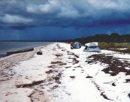
This is the East Cape camping zone. I would NOT recommend it as a Summer site, unless you have a good tarp with sturdy poles, ropes, and stakes. As you can see here, there's no shade on the beach. If you go back into the vegetation away from the seabreeze at the beach, a squadron of crack mosquitoes will make a major blood donor out of you whether you like it or not.
You need a way to check weather reports here. I can say from experience that it's no fun here in a storm.
Last time I was here, a fishing boat zoomed in and dropped anchor no more than 100 feet from me as I was unloading my tent and stuff. I hadn't even been there 5 minutes! I continued unloading and didn't worry about them seeing me. With all those empty miles of water and beach, they didn't need to anchor that close. I figured if they were bothered by my nakedness, maybe they'd leave give me some room. Alternatively, if they weren't bothered, maybe I would help introduce them to naturism. They had their fishing lines out maybe 5 minutes, then left.
Overall, it's a great naturist site except for the tourist rush from January to about April, and except for the hottest part of Summer.