April 2000 - Canoeing Through Hell's Bay and Back(a clothing optional trek)

Jason paddles the Hell's Bay Canoe Trail
A while back, Jason, a coworker of mine heard about my wilderness trips and saw these web pages and thought this wilderness camping thing sounded good, particularly with a canoe. While he is not a nudist, he didn't think he'd have any problem camping with one. So I planned an Everglades canoe trip. There were two major overnight canoe trails in the Flamingo area and it had been a while since I'd been down there, so that's where we headed.
When we arrived we found that our preferred canoe trail, the Bear Lake Canoe Trail, has been designated as abandoned by the park service due to extended silting and overgrowth due to excessively long dry spells. That left the Hell's Bay Canoe Trail. We decided since it was late in the day on Sunday that we would go a short ways, then do a longer haul on Monday and Tuesday, followed by a short run on Wednesday before driving back home.
The ranger raised his eyebrows about our plan to go from Pearl Bay through Hell's Bay and across Whitewater Bay to South Joe River on Monday, but didn't try to talk us out of it. (Later we wished he had tried.)

ABANDON ALL HOPE
The Starting point to Hell's Bay Canoe Trail.
The Park Service STRONGLY recommends buying a navigational chart if you are going to go from Hell's Bay to Whitewater Bay or vice versa. The navigational chart shows the section from the starting point here to the first campsite (Lard Can campsite) as a nearly straight line. This is an extremely cruel joke on the mapmaker's part. The first part of the trail makes a pretzel look pretty straight. A new field of mathematics would have to be invented to study the geometry of this trail.
You are mostly turning hairpin curves for the first 170 markers or so. The markers are placed so that after you pass them you can look back and see the turn you just missed. Every major turn has a marker, and most of them are numbered. I would like to know who managed to find this route initially! The individual was clearly either a trailblazing genius extraordaire, or an incredibly dangerous psychopath. (The jury is still out on that one.)As stated above, it was relatively late in the day to start canoeing. It was around 2:00 PM. As soon as we got around the bend from the road, we stopped to put on sun screen and bug repellant, and I got into my canuding "uniform" (which I then wore the rest of the trip). After an incredibly long time for a short canoe trip, we spotted a campsite which the binoculars informed us was the Lard Can site. Finally, the nautical chart actually started showing bends, islands, etc., right where they should be. On realizing that the $7.50 map would actually be of some use now, we rejoiced greatly (or at least I did).

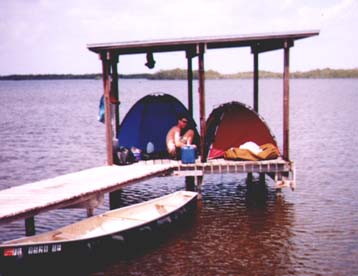
The Pearl Bay Chickee became visible not long after leaving Lard Can behind. This chickee is unusual in that it has been designed to be handicapped accessible. The platforms and port-a-john are extra wide, a railing extends around the platforms, and there is even a canoe "garage" with steps making it easier to get from the canoe to the platforms. (Usually getting into or out of the canoe is a vertical climb.)

Though it may look cramped, the Pearl Bay Chickee had enough room for both tents and "walk around" space. We refrained from setting up on the other platform, since we had no way of knowing if the other platform was reserved or not. Murphy's law clearly dictates that if you set up a tent on each platform, someone will show up and you will have to move one of your tents.
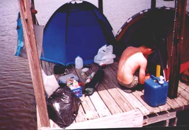
I did have to wait for Jason to get his tent situated before I could finish setting up mine (that dark blob at the back of the chickee).
Finally, I get to finish setting up my tent. As stated, this was a clothing optional trip. I did all of the canoeing in the outfit shown at right. About an hour before sunset each night, it got too cool for my natural state, so I actually used clothing for what I consider to be it's only valid purpose - protection from the elements. I did have a towel in the canoe for when we passed boats very closely. I just draped the towel over my lap. If anyone really looked, they would have still known I was nude, but they wouldn't be able to see genitalia. No one objected or even commented about it. (To date, no one in the Everglades Park has ever objected to me being nude - even when I haven't had a towel handy.)
 | Here's that "canoe garage" I mentioned earlier. This is the only Chickee I have seen with this feature. |

I found out that this was the first time Jason had ever done a trip anything like this before (I had assumed he had). It took him a little while to get used to packing quickly to get going the next day. I snapped this shot after I had packed and was waiting. Despite his inexperience, Jason did quite well with the strenuous pace we set during this trip. I'm sure I wouldn't have done as well as a first-timer out here.
He even introduced me to a new variety of munchies - they're called Snack-Ens. I've yet to find out where to buy them, but I highly recommend them for camp munching.

Our next stop was South Joe River Chickee. This meant crossing Hell's Bay, following the entire East River, and crossing Whitewater Bay. Somehow I missed taking pictures of Whitewater Bay as we crossed it. There's several miles of open water, and even though you can see the other side, it seems you never get close until you're almost there. Of course the wind picked up and we had whitecaps, so Whitewater Bay lived up to it's name. We were rather glad to see this chickee. (Although this shot was taken when we left rather than when we arrived.) There were two men already there with one tent set up on one platform, and they were setting up another tent on the other platform. We mentioned (tactfully, I hope) that we had one of the platforms reserved, and they promptly moved one of the tents. They were a bit evasive about the subject of permits, and we think they didn't have one for this site. Shortly after we arrived, they took a trip to Flamingo (they had a fast motorboat). We think mabye they tried to get a permit at that point. When they returned, they took down their tent, and said they were going to "check out" another chickee a few miles away. (Maybe that was where they were actually supposed to be in the first place - we don't know.)

After the other guys left, we had the whole chickee to ourselves. We didn't move a tent to the other platform, because we thought someone might still show up before dark. We were a bit cramped, but no big deal. No one else ever did show up to use the chickee.
There was a houseboat which passed by, then they anchored in a little inlet just out of sight of this chickee. Here's Jason practicing his "power lounging" skills after a tiring day. We had planned on this being the longest day. The GPS said we were 10.5 miles (as the crow flies) from the Pearl Bay Chickee - but of course this does not take into account the various bends the waterways actually follow. I estimated it to be at least 12 miles. Our next day was to be about 1.5 miles shorter.
The weather was basically perfect up to this point of the trip (except a little cool for my liking in the evening), and the mosquitoes were off on vacation somewhere. A few token mosquitoes stayed home to hold down the fort, but not enough to really be bothered by.
We agreed to get up earlier in the morning to see if we could cross Whitewater Bay before the wind got bad. We were paddling East by 8:00 AM. Apparently Murphy was on vacation, because it actually worked out as planned. We didn't get any strong wind until we were almost at the East River, and then it was at our backs out of the West-southwest. (This concerned me because that represented a shift in the prevailing wind which had been Southeast to South.) After a couple of close encounters with dolphins in the East River, we arrived at the Hell's Bay Chickee around 1:00 PM.
Welcome to Hell's Bay Chickee.
As you can see, we were a bit cramped for tent space again, but we're pretty much set up except for a few odds and ends to put away.
We put the stuff away, set up hammock and lawn chair, and settled in for some serious power lounging. Around 3:00 PM we decided to bathe while the day was about as warm as it would get. (The water here was almost salt-free.) After finishing another chapter of the Star Trek book I was reading in my hammock, I decided to listen to the NOAA Weather report on the Ham Radio I had brought.
It was not good news.
A cold front was making its way down the state, and would arrive that night with 20-25 knot (about 22-27 mph for you landlubbers) winds from the North with tempertures in the 50's and rain. In this picture, all that open water is to the North. Can you say "No windbreak"? Can you say "Windchill factor"?
We discussed the idea of going on back to Pearl Bay, which had shelter from the North, but we had no guarantee that it was not already reserved. We also had about 4 hours of daylight, and about 3 to 3.5 hours of paddling time to get back to the truck. We even discussed just riding out the storm right here, but figured why do that when we didn't have to. We decided to go for the truck

The Evacuation Begins.
According to the Park Service information we had, it is 12 miles from Hell's Bay to the head of the canoe trail at the main park road. We had already travelled about 10.5 miles so far from South Joe River, and would pass right by the Pearl Bay Chickee again. In essence, we were about to complete the entire trip in reverse in one day instead of the two days it had taken to go out. A 22+ mile day is not that big of a deal when canoeing with the current on a river, but against wind and tide currents with one inexperienced trekker and one trekker who's gotten too used to using motors lately, this was a significant task we were about to undertake. At least we had had a three hour rest break.
A three hour restbreak....
The wind - it started getting rough, the tiny ship was tossed...
Sorry about that. I couldn't resist.
Other than being physically taxing trying to get back to the truck before dark, it was fairly uneventful. We could only go so fast in the narrow winding channels - we were mostly turning the hairpin turns.
We started a countdown of marker numbers. From Lard Can back to the road, you pass over 170 markers, and we counted each one off.
After sighting a glimpse of the road through the trees, we stopped so I could get into textile mode in case someone was at the trail head. It may have been unneccesary. The only person there had apparently just gotten dressed himself (or at least changed). He left in his car toward Flamingo on the main park road (away from the park exit), then pulled over several hundred yards from my truck. A few minutes later, he pulled back onto the road, turned around, and drove by toward the Park exit. We knew for sure he was now shirtless. I kind of wonder if he was driving home in the buff? I guess we'll never know.

We got the truck loaded and ready to roll just before dark. It was 8:00 PM when we pulled onto the main road headed out of the Park to start our 7 hour drive home. (At least for me. Jason had another hour and a half to go after that.)
It was one long day, but at least I had no motors break down this trip, no oars or paddles break, and as a result, did not have to be towed in! (See Everglades 99).

(OR USE YOUR BROWSER'S BACK BUTTON TO RETURN TO PREVIOUS PAGE
