(Wilderness Interuptus)

The adventure fixes to commence to begin
The adventure fixes to commence to begin
Tropical Storm Bertha was sitting in the Atlantic. Probably it would steer clear of Florida, but I didn't want to have to race back in from the middle of the Everglades if it decided to pay us a visit. Besides, I hadn't been on the Kissimmee River since they'd restored the section south of Avon Park Bombing Range.
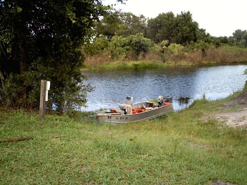
So Kissimmee River it was. We put in at the boat ramp just north of Highway 98 at the lock. The plan was to go upstream to Rough Island between Lk Hatchineha and Cypress Lake if possible, then back to the starting point.
We used my 14 ft V-hull, with 25 hp motor (Bertha), and 3.5 hp backup motor (Nissie). Mike, who's gone on past trips went along.
The restored section of the river begins almost immediately north of where we put in. Within minutes of starting out, we were twisting and turning on the historic river channel.
(The Army Corpse of Engineers made a straight 'ditch' of the river in the 1960's. Decades later, enough people realized what a huge mistake that was, and and a lot of time and expense has gone into partly correcting that mistake. A section of the 'ditch' has been back-filled, and the river flow now follows the original route)

The Kissimmee River for Dummies
The current in the historic channel is substantial in contrast with the current in the 'ditch'. The 'ditch' is like 30 feet deep, while the historic channel is a few feet, so all that water has to really move along.
The best speed we could make upstream here was 11 mph with the 25 hp outboard. It wasn't long before we hit a snag. Literally.

I thought we would clear the submerged tree, but part of it decided to find our propeller. The shear pin willingly gave it's life to protect the engine's drive-train.
Likewise Nissie, my faithful 3.5 hp Nissan outboard, picked up the slack and pushed us along for the rest of the historic channel at a sedate 2 1/2 to 3 mph. Once we emerged into the 'ditch' at the north end of the historic channel, we moved upstream against the reduced current at a peppy-er 4 1/2 mph.

Mike , naturally
Though it was 4th of July weekend, there was no boat traffic. (We had started the trip in only Indian-style breech cloths, thinking there would be too much boat traffic at close quarters for us to travel nude.) After a substantial time with no traffic, we doffed the breech cloths. After all, the original (pre-Seminole) Florida Indian men generally didn't wear clothes in Summer. We were prepared to cover up if needed in case we did encounter boat traffic, but it wasn't necessary.
I had hoped to camp on an island near the site of Ft Kissimmee. The Avon Park Bombing Range occupies the whole western shore of the river here for miles and miles. Turns out the island I was interested in is the ONE place where the bombing range boundary crosses the river (or so the official signs warned). We continued northward.
We donned our breech cloths again as we neared the S65B lock and dam. I wasn't sure how the lock attendant would react to our minimal attire, but we were covered after all. We needn't have worried. Not word one was said about the breech cloths. Later I noticed from the location of our "Nudist in the Area" signs in the boat, that they would have been clearly visible from the lock keeper's vantage point.
Landing at Kicco
We made camp at the site of Kicco (pronounced "kiss-o"). Kicco was once the only 'civilization' in this area. The steam powered riverboats on the Kissimmee River were how folks traveled here. Kicco was an acronym for 'KIssimmee Cattle COmpany'. The cattle in this area were shipped along the river to markets. Now the site serves as a hunt camp, as well as a campsite for boaters and Florida Trail hikers.

Me in camp at KICCO. At the lower left, the white patch is part of one of the old town's sidewalks. The Florida Trail actually follows this sidewalk briefly.
KICCO was a nice campsite. There was an abundance of racoonly visitors during the night. My guess is many campers here fail to secure their food at night, so the 'coons are used to being well-fed when they see tents.
I was able to easily remove the 25 hp propeller, but of course had no spare shear pins. I kept the prop off so I could use it for sizing any shear pins we might find later.
Mike looks for dinner fixin's.
Shortly before dark, we were surprised by a couple of airboats that passed by on the river. They didn't come ashore.
We got up with the daylight and without particularly rushing were underway before 8 AM.
After we were well underway, I remembered River Ranch Marina was ahead, before S65 lock and Dam. I decided I would check them out for shear pins. When we reached the turn-in for the marina, I saw the phone number on their sign, and realized I could call ahead. If they didn't have shear pins, I could save 15 minutes or more by not going in.
The number posted rang an Orlando office of River Ranch's parent company, Westgate Resorts. The lady I talked to prefunctorily informed me that this was Westgate Resorts, not a marina. I then read her the sign in its entirety, emphasizing the word 'marina' when I came to it. She informed me River Ranch was a resort hotel. Again, I read the part of the sign that said Restaurant, Lodging, and marina. She said she had no information on the marina, but she could probably give me their direct phone number, but she didn't have it! (A worse than useless call, since it yielded me no info, AND cost me air time on my cell phone.)
I decided to go in to the marina and find out. I had heard River Ranch was upscale, so we actually broke out shirts and pants rather than go in our breech cloths. We eventually found the marina office/store hidden away on the North side of the Restaurant building. A sign on the door said closed Monday, Tuesday, and Wednesday. Again, worse than useless due to the wasted time coming in there and looking for the store. (How hard would it have been to print Thur. - Sun. On the sign out by the river, rather than the useless Orlando phone number? Thank you Westgate River Ranch - for nothing. At all.)
This process of fully dressing before going into the marina became a pattern for the rest of the trip. Hence the subtitle of this report. We basked in periods of wilderness, interspersed with bouts of civilization (silly visation).
We returned to natural form at the river, but too soon had to put the breech cloths on for the S65 lock. Prior to the S65B lock on the first day, Mike had never traveled through a lock before, and he was still fascinated by the process.
Grape Hammock Fish Camp and Marina is not far from S65. After 'getting civilized', we went in there in search of a shear pin.
Grape Hammock was everything River Ranch wasn't - knowledgeable, friendly, helpful, and open for business. They didn't have shear pins, but their maintenance guy didn't hesitate to offer to drive me to a nearby outboard motor shop. That shop didn't have shear pins for my 1969 vintage motor, so we headed back. He then went to his workshop and brought out a large nail and asked me to see if it would fit the shear pin hole in my prop shaft. It did. Using my prop as a guide for size, he then cut 4 correct-length pieces out of 2 nails. He handed me a file to remove the burs, then started to walk away. I asked him what I owed him, and he said "nothing". I tried to insist he earned something, but he wouldn't agree.
I thanked him and went to the marina store for a snack and drink. Looking at the gas tank for the 25 hp motor, I decided to top off our fuel supply. We left with 3 full tanks, just like we started with (we had nearly used one up).
Clouds were looming as we left Grape Hammock, but I thought with the 'big' motor back in commission, we could get across Lake Kissimmee before getting stormed on. I was wrong. We ended up having to stop near a wooded shoreline and 'hunker down' in the boat till the thunderstorm moved on.

After the storm, we went on to Lightsey Point. The water was still churned up, so it was a rough ride. We set up camp well before dark. We were able to explore the place a bit as well, despite the misty rain that persisted for some time.
We checked out the South Florida Water Management District sign,
As well as the nearby Osprey nest.
We also saw a couple of bird nesting boxes Troop 712 had put in place.
Only one boat (an airboat) went by that afternoon/evening. The rain had actually made things cool enough it was hard to believe it was July.
The wind was starting early, so we wanted to get off Lake Kissimmee as soon as we could. So we planned on using 'Bertha' (the 25 hp) as opposed to Nissie. I noticed there wasn't much left of yesterday's full tank, but figured it would get us the short distance to the river at the north end of the lake. It didn't. We ran out within sight of the river entrance.
Rather than change tanks, I swapped motors and put Nissie back We then proceeded up the river at a screaming 4 mph.
Bertha had used 6 gallons crossing Lake Kissimmee! Considering the speed (11 - 13 mph), this was bad. Figuring another 6 gal. to come back across the lake, , that only left 6 gallons. Not enough to get back to the truck. We would have to rely on Nissie for most of the trip, using Bertha to cross Lake Kissimmee.

The cow bridge
A short way upriver from the lake, we saw cows crossing the river. On a bridge. Okay.
Next stop was Camp Mack, a marina on a still-open section of the historic channel. If you stay in the 'ditch', you'll miss this marina. Like Grape Hammock, the folks here are friendly and helpful. We got gas again, as well as sodas and ICE CREAM.
Back on the river again. Mike was at the helm.

Captain Mike
The river opens up into Lake Hatchineha as you continue northward. There are several campsites on 'Hatch'.

The Yacht Club
On the East shore is a tin-roofed, open air (no windows or screen) shelter. The local airboaters call it the 'Yacht Club'. The sign below is hanging inside. Note the spelling 'correction'.
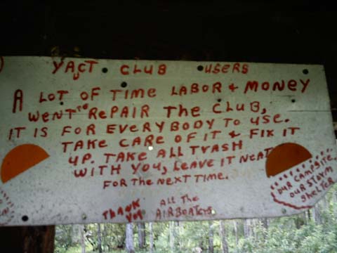
The Sign
One nice feature of the Yacht Club is the well (if you don't mind sulfur water).
The Well
I do like sulfur water, so I tank up whenever I'm there.
Deluxe sulfur water
We wanted to hang stuff to dry before the afternoon storms, so we soon left the Yacht club behind for our campsite. We saw how low the water was and knew Rough Island wasn't an option, so we set up camp at Candler's Point.
There wasn't much drying time. The worst storm of the week started just after lunch. The wind was so strong, the tent poles bent down and laid the tent on top of us. We're talking 40-50 mph winds.
Before the rain actually started, we were stunned to hear and see the tourist airboat leaving Camp Mack and heading out into the storm! There was no mistaking it. The bright red airboat was full of riders.
Despite the ridiculously high winds, frequent lightning, and minimal visibility (once the rain started), the riders got the full 'tour' of the lake. Go figure.
It rained well into the night. Just before dark, for no apparent reason, my air mattress decided to start leaking right on an edge seam where I couldn't begin to repair it. Cold, damp, and sleeping on the hard ground. Good times.
Time to head back South. We couldn't resist stopping at Camp Mack again for soda and ice cream. Thence, on to Rabbit Island in Lk Kissimmee.
Since winds were calm, we used Nissie to save fuel. It was a nice ride, and we reached Rabbit island by 10:30.
Landing at Rabbit Island
Near the boat landing is a derelict houseboat. Obviously it got there during much higher water, possibly in a storm.

While a bit warmer than we might have chosen, the weather at Rabbit Island was perfect for drying tent, sheets, towels, laundered clothes, etc.

Drying out
There was a stilt cabin on the island for years. The hurricanes of 2004 (Charlie, Frances, and Jeanne) left it in ruins, but the floor and stilts are still there.

The space under the floor can sometimes be the only practical place on the island to stay cool in the summer heat. We made use of this shade in the heat of the day, reading and listening to shortwave radio.
We also explored the island a bit, careful not to stay in the sun too long.
As nice as Rabbit Island was, we had a long way to go in the morning. (Farther even than we thought.) We put Bertha back on the boat to make the best time.
We were across the lake and passing the Grape Hammock Marina entrance by about 8:30. Since they had been so helpful, we decided to throw more business their way and get sodas and snacks.
Not long after that, we were back underway and headed for S65. It took a while to roust the lock keeper, but it was otherwise uneventful, and she didn't seem to mind or notice our breech cloths.
The plan was to camp just south of the island that we'd found was in the bombing range before. We locked through S65B again, dropping about 8 feet.
Turned out the sought-for campsite was ALSO in the bombing range according to a sign we found there.
We continued motoring down the 'ditch'. We had consumed most of our food and water, and much of our fuel, so were significantly lighter than we had been when going upriver. Bertha was now propelling us at 14-15 mph. I actually throttled back to 12-13 mph to save gas!
We ran out of 'ditch' before finding a campsite, and continued down the historic channel. After Rabbit Island, I wanted a shaded campsite. The 2004 hurricanes apparently took out a lot of trees in this area. It was hard to find a high spot with a place to land the boat AND shade. We finally found this one.

We set up camp and spent the rest of the afternoon power lounging.
Soon after arriving, we witnessed more river traffic than we'd seen all week. Turned out, some of that traffic was people looking for us! (They didn't know us particularly. They were looking for the owner of the truck that had been parked near the boat ramp for days.) One of the boats stopped and asked if we belonged to the red truck by the ramp. I said yes, and he went to tell everyone we'd been found.
It seems we were supposed to tell 'Leroy' we were camping on the river. Leroy is the manager of the campground near the boat ramp. (I had seen a sign asking people to check in, but assumed it meant people camping at the campground.
It rained enough to cool things slightly before evening. Otherwise, it was an uneventful evening (we thought).
We put Nissie back on the boat. Bertha was about out of gas (Nissie has her own tank), and it was a short run downstream.
Within an hour we were in sight of the boat ramp when Nissie ran out of gas. I refilled her, and while trying to restart her noticed gas dripping out of the cowling (not normal).
By the time I had unstuck the carbuerator float valve and restarted, Mike had a shirt and shorts on. I was still in breech cloth, but I did throw on a T-shirt before reaching the boat ramp.
At the ramp, a State Officer stood by his official boat, waiting for us to land so he could do a safety check. He saw the lifejackets and fire extinguisher, and I produced registration and whistle when he asked. As we talked, I put pants on over my breech cloth. Our 'Nudist in the area' signs were clearly visible in the boat.
The officer chatted about the sunken boat, and airboat propeller injury someone had suffered, both within a short distance of our campsite the previous evening. He also mentioned we were supposed to have gotten a permit to camp in this section of river. He didn't cite us, but advised us to get one next time. Nudity was not mentioned.
My winch on the trailer was somehow stripped out when we tried to bring in the boat. It had not been that way before, and I have no idea what happened to it. I had to haul the boat out with it partly sticking out from the back of the trailer until it was on level ground.
Other than that, it was an easy trip back home.