Ocala Forest 2000

(I apologize in advance for the poor map images in this report. Maps are hot-linked throughout the text rather than taking up too much space with them.)
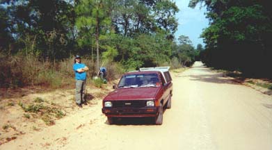
I had a friend drop me off at Forest Road 77 (FR77) with my truck. This is at the extreme North end of the forest. The plan was to pick me up at State Road 40 by the entrance to Juniper Springs (roughly the middle of the forest). Bruce has provided transport and even gone himself on a few of my wilderness outings. He is rather devoutly textile himself, but is not bothered by the idea of nudism/naturism.
He was a bit perplexed when I stripped off my T-shirt and shorts and put them in the back of the truck before putting on the pack. I explained I had a towel to cover up if needed, but when I explained I wouldn't be wearing any clothes all week, and why should I bother with the extra weight to carry any, he still shook his head and said something to the effect of "how boring my life would be without people like you in it". (I guess that's a polite way to call someone crazy.)

Because this hike was to be Monday - Friday with no holidays nearby, I didn't think I would be meeting too many folks on the trail - if any. There was also a drought going on, so I needed to carry more water than I normally would (1 gallon rather than 1/2). Partly to compensate for the extra weight, and partly since I planned to stay nude, I packed no clothing except for socks. I did have a couple of towels, but I always have towels anyway. I figured if I really needed to cover up on the trail, one of my towels would do the job.
My first stop was to be the area around Grassy Pond (about 11 miles). Those first few miles were very non-typical for Central Florida hiking. The terrain was mostly rolling hills. In one area the hill was so steep there was actually a switchback! (I'm used to switchbacks in the mountains, but this is practically unheard of in Florida.)It was basically easy hiking with a temperture in the upper 80's when I started to the lower 90's by afternoon. My first "challenge" was hiking by the Lake Delancy Recreation area. While it is managed by the Forest Service, it is basically like your commercial campgrounds with people driving the family car to their campsite. I had the towel available (tucked between my back and my pack as extra padding) in case I encountered textile campers, but all but one of the campsites I saw were deserted, and that one was too far away for them to see anything without binoculars. So my concern was unfounded.
After Lake Delancy, I concluded (as I had in 1980) that the chances of meeting anyone this week would be negligable. I considered putting my towel inside my pack to allow more airflow between the pack and my back, but decided I'd rather be sure of not chafing my back than to have that extra little bit of airflow. (The end of the towel is just visible between my left arm and side.)
The rest of the hike to Grassy Pond was during the hottest hours of the day. If I had met anyone at this point I was sure they would understand my desire to hike nude just from the heat. Just before Grassy Pond was a large clear-cut Sandpine area. (Ocala, like most National Forests, is multi-use and permits logging.) The total lack of shade and seemingly endless vista of low scrubby bushes made this part of the trail seem to take forever.
After the rise and fall of several major civilizations, I finally emerged from the clear cut area into a "normal" sandpine scrub. I knew Grassy Pond was nearby. I passed a side trail with a marker post, but no sign on the post. Rather than check it out, I pressed on. Eventually, I saw what must be Grassy Pond (although almost totally dried up), but I saw no water pump or camping area like the map indicated. I continued hiking on the theory that maybe it wasn't Grassy Pond after all.

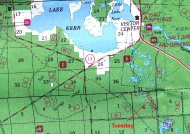
That was until I came up on FR 88. According to the map, that was in fact Grassy Pond I had passed, but I was too spent by this time to go back. I crossed the road and found the first spot by the trail I could set up camp. (The word "Monday" in the map picture indicates where I camped.)
After cooking dinner, I saw I really needed to refill at least one of my water bottles before hiking on the next day. It was now after 6 PM and I could see that the hike back to Grassy Pond might be shorter if I followed the road rather than the trail. I had heard no traffic go by since right after I set up camp, so I figured I would go ahead and take the road. I grabbed my empty 2 liter bottle, and one of my trusty towels (in case a car did come by) and went to find Grassy Pond.

The reason I had not seen the Grassy Pond campsite before was that the campsite is on the West side of the pond, and I had hiked on the East side. This is some of the terrain you are hiking through before reaching Grassy Pond area. (Turns out that side trail I had seen came straight into the campsite behind the Latrine area. If I had followed it, I could have had the whole Grassy Pond camping area to myself with all the cold well water anyone could want, plus several picknic tables and an actual flush [chemical] toilet.) Though I didn't get a picture of this campsite, I would highly recommend it during warm weather weekdays for naturist camping. Weekends, I don't know. The site is accessible by any good off-road vehicle. Any truck with good ground clearance, some weight over the back wheels, and wide tires could probably navigate the loose, thick sand road to get to the campsite. My guess, supported by several beer bottles and cans I saw, is that on weekends it's a redneck party spot. (Probably not the best neighbors for a naturist camping group or individual.)

Maybe a mile down the trail, I came on a blue-blazed side trail marked with just the word "water". Since I had just tanked up and had a long way to go yet, I didn't stop to investigate. I hiked on till lunchtime. Consulting the map during lunch, I saw I had two more major road crossings left for the day. Highway 314 and FR88 (which was actually paved from here on South). From my experiences so far, I new they would be no big deal.
As I approached 314, I saw a white van through the trees. I wondered if someone had parked there to hike. (I had been following footprints someone had probably left on Sunday. Nothing fresh, but I figured if I'm hiking, maybe someone else is crazy enough too.) I soon saw this was not the case. I saw a green star on the side of the white van, which in Florida usually means it's a county sherriff. And the sherriff's office usually only uses vans to transport multiple prisoners.
Sure enough, I started seeing orange vests through the trees ahead. The jail road-work crews wear the vests for increased visibilty when they are doing road-work. As I got closer yet, I realized that of all the places along the highway they could have stopped, they picked the TRAIL CROSSING for their lunch break!
I didn't have the time to sit and wait for them to move on, so I wrapped the towel around my waist and cinched the hip strap over it to keep it in place, then as casually as I could, walked through the group, crossed the road, and continued on the trail on the other side. Surprisingly, the only words said by anyone was a friendly greeting by someone in the work crew. Once out of sight of the group, I stopped to restow the towel behind my back. Amazing how uncomfortably warm that towel was for just 200 yards or so of hiking in it!
My next destination was a group of ponds northwest of Hopkins Prairie (marked "Tuesday" on the map). I figured on being able to refill my water supply there, as well as cook with the pond water. (I carry purification tablets for drinking water on these trips.) As the first day, I was hiking about 11 miles. It's a good thing I hadn't planned any more, because I just wasn't in that great shape. When I arrived at the ponds I was looking for, I was too spent to continue.
The ponds were bone dry. (Remember the drought.) I had to ration my remaining water until I could replenish at Hopkins Prairie the next day. Other than that, it was a nice campsite, I thought.
After setting up camp, I wandered around a bit, and found not only was it excellent "bare country", but that it was in fact bear country as well. I found a pile of bear droppings about 200 feet from my tent. Needless to say, the food spent the night in the bear bag that night.
 |  |

Here's the nearest "pond". Looked more like a meadow with the drought.
Just before moving on the next day, I heard a dirt bike or ATV coming up the trail West of me. (All motorized vehicles are prohibited on the trail). Whoever it was turned off on a side trail on the other side of the pond.
In all the years I have backpacked (at least 25) I have never developed a blister on the BOTTOM of a foot (where I already had a good layer of callous). Somehow I had managed to do that before reaching Grassy Pond on Monday, and the foot wasn't appreciating the fact that I was pressing on regardless. I just decided to keep a slower pace and get there when I got there. According to my GPS, I had slowed from 3 mph the first day to about 2 mph.

Earlier in the trip, I had wondered if there was a way to bypass Hopkins Prairie, because the trail does not go NEAR it, it goes THROUGH it. Hopkins Prairie, like Lake Delancy and Lake Kerr, is a drive in camping area. I really didn't want to deal with crowds of "car campers". After having seen Delancy and Kerr, I now expected to find Hopkins Prairie to be fairly deserted. When I arrived at the Northwest end of the lake and saw it was almost totally dried up (the sand in the picture is the normal shoreline), I now wondered if there would be anyone there after all.
I got an early enough start to be started around the lakeshore before the sun really got hot. This would be a killer hike in the afternoon, since it would not only be hot in general, but the trail is on the East side of the lake, and there would be no shade in the afternoon. Turned out it was a very nice hike around.
As I finally got within sight of the peninsula the campground is located on, I saw a white Blazer or Suburban type vehicle seemingly parked at the very tip. The trail wound a couple more times, then went behind a large stand of trees (possibly an island when the water is up). When I emerged from behind the trees, I did not expect to be able to see the vehicle because of the new angle, but it had apparently moved. As I approached further, it was obscured by intervening foliage. As I entered the North edge of the campground, I could see a number of empty campsites. Two dogs wandered across the road just then, and I wondered if there would be anyone following the dogs. There wasn't.
As I entered the center of the recreation area, I could again see the white vehicle. Its doors and windows were closed up, and there was no tent or other sign of people. It was too hot for someone to be sitting inside the closed vehicle. The license plate was out of state. It occured to me that it might be someone doing the tourist thing with two vehicles. (Forest Service campsites are $4.00 a night - much cheaper than a hotel room.) No doubt the owners would be back that evening with their other vehicle.
Now that I concluded there was in fact no one there (I decided the owner of the white vehicle had left his/her dogs behind to watch the vehicle), I found a picnic table near the large hand-operated water pump, and set my pack down. I immediately filled my water bottles, then put the towel on one of the benches, and sat down to have lunch. I was going to put my trash in the plastic bag I had been carrying in my pack, then remembered I had seen actual trash cans a few minutes before. Once my lunch was finished, I took the trash plus some trash from my pack to the cans.
On the way back to my pack, I noticed that beyond the white vehicle, I was now seeing something dark and rectangular I had not seen before. I decided it looked like a blanket or sleeping bag on a clothesline. As I watched, a man walked into view between the trees carrying another blanket or sleeping bag and threw it on the line as well. He had his back to my direction. The second item he put on the line began to slide off, and he leaned kind of sideways to catch it and put it back up. When he did this, I was able to see his whole back and down to about the middle of his butt. He was very tan, and either was nude or had shorts on the same color as his back. I didn't see him again, but I was able (now that I knew where to look) to see glimpses of ANOTHER white vehicle through the bushes. This was probably the first one I saw, and explained why the second one seemed to be in a different place.

I put my pack back on, and began hiking out the road to find where the trail continued on South. I passed another campsite with a vehicle but no tent in it. This was a Florida vehicle, so it may have belonged to another trail hiker. I never saw anyone
Just southeast on the trail from Hopkins Prairie is a rather interesting sink-hole lake. I thought about a quick skinnydip, but I could see a road on the other side of the lake, and Hidden Pond (today's destination) was supposed to be swimmable anyway. I decided to trudge on.

The next point of interest was the entrance to the Juniper Prairie Wilderness Area. Wilderness areas are just that - wilderness. They are not managed for timber like the rest of the forest. I knew this, but did not realize there would be such a visible difference between the two areas. The best single word I can think of to describe the appearance of the Wilderness Area is "gnarly". Twisted, broken limbs and trees were crowded in together quite unlike the rather open forest I had been hiking in.
The first point of interest inside the wilderness area is Pat's Island. In the book "The Yearling", Rawlings describes "islands" of oaks rising from the pine scrubs. Most of the action takes place near Baxter's Island and Forrester's Island. Here was an authentic example of such locations. All that I saw (I didn't take the time for an extensive tour) was an old cistern, shown above. The Forest Service has a fence around it to keep people from falling in. Next time I'm in the area, I think I will check it out more extensively.
After having seen all the dried up ponds on this trip, I began to wonder if Hidden Pond would be gone too. I needn't have worried. As I was going up a rather parched hill through the scrub, I began hearing frogs. As I crested the hill and started down, there was Hidden Pond below. (That's the Hidden Pond marker sign I'm leaning on. An Ocala Trail marker shares the post.) The pond's not really hidden, but the sense of suddenly coming on a pond in such a dry area explains the name somewhat (What's a pond like that doing here?). Most likely it is a sinkhole pond, since it was deep enough to not be dried up.
The camping area is on the West side of the pond (opposite the trail). Beyond the campsite further West is another, much larger but shallower pond. This pond was dried up except for a few spots, but along its East and North shore are more campsites. Between the main site and the other sites, you could easily accomodate half a dozen groups of hikers without feeling like you were in a commercial campground.
Remember, my plan was to hike vigorously Monday - Wednesday, then take a day off to "power lounge" before hiking back to civilization on Friday. I set up my hammock before setting up the tent and relaxed a while Wednesday afternoon. Of course, I had to take an obligitory dip in the water too.

Thursday, my official power lounging day, I hiked around the larger pond without my pack, and with just comfortable shoes rather than my hiking boots. I also got wet in the pond a few times, and of course read a book in my hammock. I didn't bother carrying a towel around for any of this. By this time I had decided that since only hikers could get here (no vehicles allowed), and since serious hikers are pretty much back-to-nature and would probably understand skinnydipping and going nude on a hot day, that I didn't need to worry about freaking out anyone. Besides, I had met not one soul on the trail so far either. (Although in a way, I actually hoped I would get "caught nekid" by the pond just for the opportunity to introduce someone to naturism.)

Somehow, I forgot to take a picture of the actual campsite. I did get a picture of one of the other campsites from a distance accross the dried up pond (under the trees in the center), and one of Hidden Pond itself (below)


This is what the area around Hidden Pond looks like. A forest fire burned the larger trees several years ago, and the new growth is coming back. These rolling sandy hills give the place a very barren, desolate look. Notice how the trunks of the standing trees are leaning in one direction for the most part. This area is close enough to Lake George to get a mini-seabreeze all afternoon from the East (Lake George is the second largest lake in Florida). Sand pines are somewhat limber, and they tend to take on a Westward bend in response to this steady wind.

The trail from Hidden Pond out of the Wilderness Area was especially gnarly and unkempt (as would be expected with no one to "kempt" it). In places, the brush was so close my legs brushed through it, and I stopped several times to check for ticks. Good thing, since I found a number of them. One of the advantages of hiking nude is that the ticks don't have all the nice hiding places under clothing, so if you check periodically, you can get them off before they dig into your skin. Also, I've noticed that bare skin just doesn't seem to pick up as many ticks in the first place as clothing does. I've seen jeans legs covered in ticks before, but I've never found more than a half dozen at a time on my bare skin.

A long segment of the trail went through "tunnels" of sandpine saplings like these. I actually had to turn sideways a couple of times to allow my pack go get through (due to my rolled tent sticking out the sides)
Day five was Friday, and it occurred to me that some people do get an early start on the weekend, and that I might encounter other hikers coming in. I decided that at least as long as I was still in the Wilderness Area, I would not cover up if I did meet anyone for the above reasons. When I got to the boundary of the wilderness area, I knew would have to be alert, since there are jeep trails and a nearby Recreation Area (Juniper Springs)
As it turned out, there were no more people on Friday than the rest of the week. After leaving the Wilderness Area (boundary marker shown at right), I arrived at the entrance road to Juniper Springs without encountering anyone. Now I had no choice about putting the towel around my waist though. The entrance road had a fair amount of traffic coming and going, and I needed to wait for my ride by this road. I put on the towel, and put my pack's hip strap over it to hold it in place, and hiked from the trail down the entrance road out to Highway 40. Just as I stepped onto the entrance road, I saw my truck turn in from Highway 40, turn around and go back East on the Highway. I continued to the Highway, and stopped to wait at the sign for Juniper Springs. It was still 20 minutes before our scheduled rendesvous. I figured if Bruce was not back with the truck at noon, I would start walking East along 40 until I met the truck.
About 10 minutes later, Bruce returned with the truck. He had seen a trail crossing sign back East on the Highway and wasn't sure where to meet me. It really felt strange to put clothes on after 5 days, but we WERE going back to Silly-visation after all!
All in all, an ALMOST perfect week of nude hiking. A little more rain would have been nice beforehand to fill up the ponds, and the night time temperatures could have been in the 70's instead of mid-to-lower 60's (this was supposed to be Florida in May, after all).

(OR USE YOUR BROWSER'S BACK BUTTON TO RETURN TO PREVIOUS PAGE